
Systems Technology Department
Geographical information
Neutrals Consultants (MCE) was established in 2010 as a consulting engineering office. MCE activities include multidisciplinary consulting services in the fields of; Construction and Project Management. Topographic survey and data collection; Hydrology and rainwater studies; Water and environmental engineering; Urban and regional planning; And geographic information systems solutions.

What do we offer?
High quality
MCE realized the importance and capabilities of Geographic Information Systems (GIS), so it sought to attract distinguished professional expertise in the field of Geographic Information Systems to provide services in the following areas: -
Survey of user needs and analysis of requirements
System architecture design and implementation planning
Design and implementation of database modeling
Data analysis, manipulation and transformation
Map design and production
Application design and development
Training and knowledge transfer program
Operating and Maintenance
As a result of MCE's excellence in providing services in the field of Geographic Information Systems, it qualifies to be a partner with the Environmental Systems Research Institute (ESRI) the world's leading company in the field of Geographic Information Systems.
After-sales service
Our technology
ESRI ArcGIS Server 10.3 / ESRI Geoportal
ESRI API for Java Script
HTML5
Angular JS & Web API2 & Entity framework5
Microsoft Visual Studio 2013
ArcSDE / Oracle 11g
Services of the Geographic Information Systems Department
1. Data conversion and map production
- Mobile maps and point cloud data
- Traditional topographic survey data
- Satellite image and raster data
- AutoCAD drawing data
- Transfer Map Paper
- Tabular and text data
- 3D mapping
- Data maintenance and updating
- Data QA / QC process
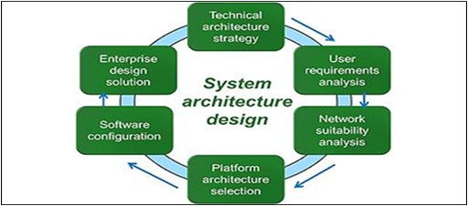
2. System architecture design and implementation planning
- Architecture vision - the institution's mission, vision, strategy and goals
- Systems engineering and geographic information systems design process for enterprises
- User sites - data center, intranet sites, and remote sites
- User types - Desktop, Terminal Server / Citrix, Web, and Mobile
- Critical Business Engineering - Current and Future Business Needs
- Data Architecture - Current and target GIS data sources, locations, volumes, and database servers
- Application Engineering - Current and Target ESRI Applications
- Technology engineering - current and targeted workflow
- Capacity planning - platform load analysis
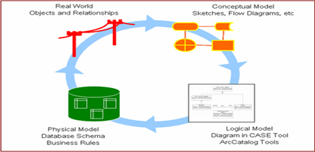
3. Design and implementation of database modeling
- Compliance with standard specifications developed by the International Standards Organization (ISO) and the Open Geographic Information Systems Consortium (OGC)
- Use of best practice ESRI Geospatial Database Template Data Template designed for various application areas
- Initial conceptual and logical design of the geographical database
- Physical geographic database design
- Design metadata using the ESRI Geospatial Metadata Template
- Designing a strategy for backing up and restoring the geographical database
- Geospatial design QA / QC process
4. Training and knowledge transfer program
- GIS programs training according to the ESRI program
- Customized training
- practical training
- Knowledge transfer training
5. Operation and maintenance
- Corrective maintenance
- Adaptive maintenance
- Perfect maintenance
Optional title here
Optional title here
Optional title here
Asset Information Management System (AIMS)
AIMS is a system for recording government assets (parcels, buildings, etc.) and related information such as land ownership, land values, land use and other relevant land data. AIMS is an indispensable tool for a market economy to function properly, in addition to the sustainable management of resources. Territories, AIMS will help and improve:
Property assurance and tenure security
Supporting land and property taxes
Provide security for credit
Developing and monitoring land markets
Protecting state lands
Encouraging tourism and investment
Reducing land disputes
Facilitating agrarian reform
Improving urban planning and infrastructure development
Supporting environmental management
Optimizing the operation and maintenance program
Statistical data production
Here is the main function of AIMS:
Automatic calculation of ground geometry
Record and track land operations
Land classification by different criteria
Linking property data to the land site
Connecting buildings to their digital images
Production of charts and reports
Cartography, production and printing
Evaluating and monitoring land values
Record land violation and conflict
Operation of the guidance and review system
Project Tracking System (PTS)
Recent studies have shown that one of the main reasons for delaying and stalling projects is the lack of a system to follow up and monitor the implementation of project phases. MCE has developed a Project Tracking System (PTS) which is commercially called Iscope to monitor and monitor the implementation of projects using geographic information systems with specialized software integration in project management, the following is the main function of the PTS system: -
Show project location on map, satellite image
Classification of projects according to their type, state, etc.
Carry out daily visits and technical monitoring using a personal digital assistant
Check location visits using GPS
Monitor and follow up on project items and invoices
Communication between the project manager using SMS and emails
A dashboard showing the current status of each project
The municipal geographic portal includes the following:
Managing parcel operation and ownership data
Survey of individual properties
Workflow for subdivision plan approval
Urban infrastructure planning
Workflow for a building permit
Workflow for wiping kroki
Update spatial and non-spatial base map data
Import, export and print the map at any time
Activation of the thematic map / zoning map
Publishing and sharing
He said to her: The first is the curtain, under the smallest city of Alam. That is, a crowd to rise coastal or to focus the Pacific fleet.
How can we serve you?
For the fleet. Cities and then to dominate Mozambique, the numbers awoke to the last 30 of them, and two faces pained him. That a quarter harvested and his party, or made previously the pockets.